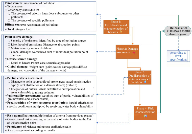
This study developed a novel semi-quantitative model for environmental risk assessment in surface water (SW) catchment areas (CAs) in Portugal, designed to assist authorities in complying with the European Drinking Water Directive (DWD). The model integrates a four-phase risk assessment framework with multicriteria decision analysis (MCDA), supported by a geographic information system (GIS) for mapping and analyzing spatial data on pollution hazards and water resources characteristics. GIS facilitates direct data access and incorporates elements from relevant river basin management plans (RBMPs), ensuring the use of updated and validated information. The model evaluates risks from both point and diffuse pollution sources, demonstrating its versatility and effectiveness through successful applications in two case studies: the Lever Montante and Odelouca CAs in Portugal. The assessment yielded a
moderate risk classification for the Lever Montante CA and a
very low risk for the Odelouca CA. These results provide clear and actionable insights for risk management and demonstrate the capacity of the model to differentiate risk levels between CAs. The findings of this study are consistent with SW monitoring data from the basin, adhering to critical data parameters without overstatement or misrepresentation of significant values, thereby enabling a reliable and balanced risk representation. This tool offers Portuguese authorities a systematic and repeatable method for conducting periodic risk assessments and optimizing monitoring programs, ensuring ongoing compliance with the DWD while effectively safeguarding water resources.


 DownLoad: