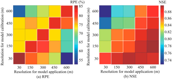
Abstract: The digital elevation model (DEM) is a type of model that has been widely used in terrain analysis and hydrological modeling. DEM resolution influences the hydrological and geomorphologic features of delineated catchments and consequently affects hydrological simulations. This study investigated the impacts of DEM resolution on the performance of the XAJ-GIUH hydrological model, a model coupling the widely used Xinanjiang (XAJ) hydrological model with the geomorphologic instantaneous unit hydrograph (GIUH), in flood simulations in small and medium-sized catchments. To test the model performance, the model parameters were calibrated at a fine DEM resolution (30 m) and then directly transferred to the simulation runs using coarser DEMs. Afterwards, model recalibration was conducted at coarser DEM resolutions. In the simulation runs with the model parameters calibrated at the 30-m resolution, the DEM resolution slightly affected the overall shape of the simulated flood hydrographs but presented a greater impact on the simulated peak discharges in the two study catchments. The XAJ-GIUH model consistently underestimated the peak discharges when the DEM resolution became coarser. The qualified ratio of peak simulations decreased by 35% when the DEM resolution changed from 30 m to 600 m. However, model recalibration produced comparable model performances when DEMs with different resolutions were used. This study showed that the impact of DEM resolution on model performance can be mitigated by model recalibration to some extent, if the DEM resolution is not too coarse.
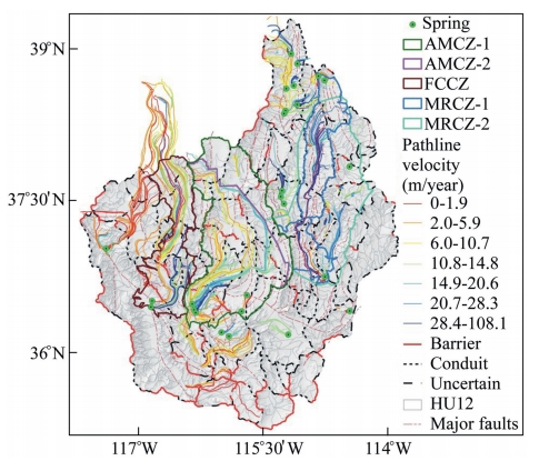
Abstract: The protection zones or capture zones of springs in desert environments can be hard to identify, but they are critical to spring protection. Most springs fed by regional aquifers are susceptible to contamination and groundwater development. The U.S. Environmental Protection Agency has established hydrogeologic mapping methods to delineate protection zones for springs. However, it is often difficult to determine a regional aquifer system's flow pattern with this technique alone, and the use of these methods is not conducive to efficient groundwater management. Particle tracking analysis using a well-conceptualized and calibrated numerical model for the three-dimensional groundwater flow domain feeding a given group of springs can help facilitate the identification of spring capture zone boundaries. Building upon this basis, a multifaceted approach was developed to define clear boundaries of the capture zones for the springs in the Furnace Creek, Ash Meadows, and the Muddy River areas in the southern Great Basin, USA. Capture zones were first delineated from inverse particle tracking and Hydrologic Unit 12 watersheds. Afterwards, they were adjusted based on water budgets, geology, and hydrologically significant faults. Finally, a geochemical analysis of the groundwater chemistry and isotopic data was conducted to verify the extent of each spring capture zone. This multifaceted approach adds confidence to the new delineations.
Abstract: Given the difficulties of degrading benzotriazole (BTA), this study used a one-pot hydrothermal method to prepare α-Fe2O3/Cu2O (FC) composites for photoelectrocatalytic (PEC) degradation of BTA. The characterization of FC structure showed that Cu2O in cubic crystals was loaded with circular sheets of Fe2O3. Owing to this structure, FC showed efficient PEC degradation of BTA when exposed to ultraviolet light. The experimental results demonstrated that FC efficiently degraded BTA. When the PEC degradation continued for 60 min, 100% degradation of BTA was achieved because FC enhanced the photoelectron-hole separation and the separation and transfer of articulated carriers. High performance liquid chromatography–mass spectrometry showed that intermediates formed during the PEC degradation of BTA. Finally, various pathways for degradation of BTA were postulated. This FC-based PEC system provides a harmless and effective method for degradation of BTA.
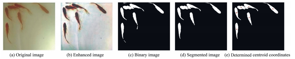
Abstract: Dissolved oxygen (DO) content is an important index of river water quality. Water quality sensors have been used in China for urban river water monitoring and DO content prediction. However, water quality sensors are expensive and difficult to maintain, and have a short operation period and difficult to maintain. This study developed a scientific and accurate method for prediction of DO content changes using fish school features. The behavioral features of the Carassius auratus fish school were described using two-dimensional fish school images. The degree of DO content decline was graded into five levels, and the corresponding numerical ranges of cluster characteristic parameters were determined by considering the opinions of ichthyologists. Finally, the variation of DO content was predicted using the characteristic parameters of the fish school and the multiple-input single-output Takagi–Sugeno fuzzy neural network. The prediction results were basically consistent with the actual variations of DO content. Therefore, it is feasible to use the behavioral features of the fish school to dynamically predict the level of DO content in water, and this method is especially suitable for prediction of sharp decline of DO content in a relatively short time.
Abstract: Nitrate nitrogen (NO3--N) from agricultural activities and in industrial wastewater has become the main source of groundwater pollution, which has raised widespread concerns, particularly in arid and semi-arid river basins with little water that meets relevant standards. This study aimed to investigate the performance of spatial and non-spatial regression models in modeling nitrate pollution in a semi-intensive farming region of Iran. To perform the modeling of the groundwater's NO3--N concentration, both natural and anthropogenic factors affecting groundwater NO3--N were selected. The results of Moran's I test showed that groundwater nitrate concentration had a significant spatial dependence on the density of wells, distance from streams, total annual precipitation, and distance from roads in the study area. This study provided a way to estimate nitrate pollution using both natural and anthropogenic factors in arid and semi-arid areas where only a few factors are available. Spatial regression methods with spatial correlation structures are effective tools to support spatial decision-making in water pollution control.
Abstract: Muddy water irrigation has been widely practiced in the Yellow River Basin for agricultural production and is an important method of economical and intensive utilization of water resources. In this study, the effects of sediment gradation, sand content, and soil moisture content on nitrogen (N) transformation were studied through a series of experimental tests. The results indicated that muddy water irrigation significantly affected agricultural soil physical and biological properties as well as N transformation. Soil bulk density, total porosity, pH, and microbial enzyme activities significantly correlated with N transformation as affected by the interaction between sediment and soil moisture. Sediment addition generally increased the soil bulk density and reduced the soil porosity and pH significantly, and the optimum moisture for promotion of the N transformation rate was 80% of the water-filled pore space. Therefore, muddy water irrigation has a potentially long-term influence on agricultural N cycles in semi-arid regions of northwestern China. This could provide a theoretical basis for scientific and rational use of muddy water for irrigation.
Abstract: Algae and cyanobacteria are known to be able to remove a variety of pollutants from water, including toxic metal ions. In this study, algal and cyanobacterial species growing in two polluted water bodies were identified, and the Pb(II) removal ability of these isolated species was investigated. Based on microscopic observations, 27 species were identified, and nine species were isolated as pure cultures. Pb(II) bioremediation of five selected species (Anacystis sp., Chlorella sp. 1, Monoraphidium sp., Phormidium sp., and Uronema sp.) was studied in detail. The mean Pb(II) removal abilities varied among these five species: Phormidium sp. > Monoraphidium sp. > Uronema sp. > Chlorella sp. 1 > Anacystis sp. The Pb(II) tolerance of each species was determined based on the live cell percentage and biofilm formation capacity. Within a period of 3 d, Phormidium sp., Monoraphidium sp., and Uronema sp. showed nearly 90% of survival, and all five species demonstrated biofilm formation capacities exceeding 50%. Furthermore, the Pb(II) removal ability of the five species exhibited a strong positive correlation with the live cell percentage and showed a strong negative correlation with the biofilm formation capacity. In conclusion, Phormidium sp., Monoraphidium sp., and Uronema sp. exhibited high tolerances towards Pb(II) and presented high removal abilities. Thus, these species can be identified as potential sorbents for development of suitable adsorption systems to remove Pb(II) from aqueous solutions.
Abstract: This review discusses high-strength wastewater treatment using anaerobic baffled reactors (ABRs) and modified ABRs. The research findings and applications of ABRs in treating various types of high strength wastewater generated from food companies, livestock, and industries were summarized and reported. Measurement parameters affecting the performance of ABRs are briefly discussed. The state-of-the-art laboratory studies are compiled and critically reviewed. Critical challenges and suggestions for future investigation are also addressed.
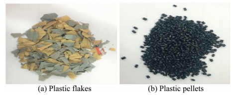
Abstract: Seepage through embankment fill materials is crucial issue in the construction of embankments for irrigation and drainage projects. Proper ground improvement methods should be used to improve the strength and stability characteristics of soil used as fill material. Utilization of waste plastic materials to enhance the engineering properties of soil is a sustainable approach. Additionally, the use of raw products directly from plastic recycling units in the form of flakes and pellets as soil additives has the potential to further enhance the economic benefits of this method. This study randomly mixed plastic materials with soil for use in the construction of earth embankments, such as river levees, dykes, and canal diversion structures, and evaluated the effectiveness of these materials in reducing seepage failures in hydraulic structures. To achieve these goals, this study collected high-density polyethylene (HDPE) plastic from plastic recycling units and used soil mixed with HDPE plastic in the form of flakes and pellets in different contents as embankment fill materials, then evaluated how these materials affected the piping features. Laboratory experiments were conducted to determine the seepage velocity and critical hydraulic gradient of soil mixed with plastics in various contents and to compare the values with those of plain soil. The results showed that random distribution of waste plastics in the form of flakes and pellets in soil is an effective method for improving the piping resistance of soil.
Abstract: Compound open channel flows appear in most natural rivers are of great importance in river management and flood control. In this study, large eddy simulations were carried out to simulate the compound open channel flows with four different depth ratios (hr = 0.10, 0.25, 0.50, and 0.75). The main flow velocity, secondary flow, Reynolds stress, and bed shear stress were obtained from numerical simulations. The depth-averaged streamwise momentum equation was used to quantify the lateral momentum exchange between the main channel and floodplain. The instantaneous coherent structures were presented by the Q criterion method. The impact of hr on flow structure and turbulence characteristics was analyzed. The results showed that with the increase of hr, the high velocity area in the main channel shifted to the floodplain, and the dip phenomenon became more obvious; the Reynolds stress largely contributed to the lateral momentum exchange within the flows near the side walls of floodplain; and the vortex structures were found to significantly increase in the floodplain region.