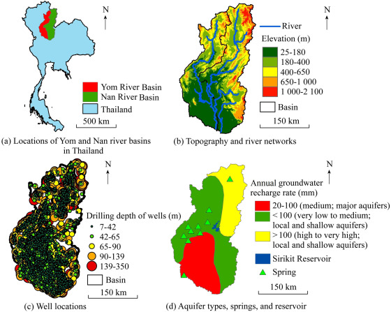
Abstract: Groundwater resources are crucial sources of freshwater, underscoring the importance of comprehensive aquifer health assessment for improved management and sustainable utilization. In this study, a novel index for assessing groundwater stress, termed the revised groundwater footprint index, was developed. The new index was compared with earlier versions in a case study of the Yom and Nan river basins in Thailand. The primary strength of the new index lies in its capacity to reduce uncertainties in groundwater stress estimation by avoiding double-counting of contaminated areas, particularly in overlapping zones, and by addressing complexities associated with multiple pollutants. An earlier-version index, known as the integrated groundwater footprint index, calculated groundwater stress in the Yom and Nan river basins as 2.75 and 2.13, respectively, significantly exceeding the maximum permissible limit of 1. In contrast, the revised groundwater footprint index yielded much lower stress values of 0.69 and 0.63 in the Yom and Nan river basins, respectively, which more accurately reflected actual conditions. The novel index can serve as a valuable tool for enhanced assessment and management of groundwater resources, supporting progress toward United Nations Sustainable Development Goal 6.4 (Water Stress).
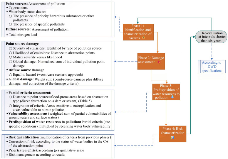
Abstract: This study developed a novel semi-quantitative model for environmental risk assessment in surface water (SW) catchment areas (CAs) in Portugal, designed to assist authorities in complying with the European Drinking Water Directive (DWD). The model integrates a four-phase risk assessment framework with multicriteria decision analysis (MCDA), supported by a geographic information system (GIS) for mapping and analyzing spatial data on pollution hazards and water resources characteristics. GIS facilitates direct data access and incorporates elements from relevant river basin management plans (RBMPs), ensuring the use of updated and validated information. The model evaluates risks from both point and diffuse pollution sources, demonstrating its versatility and effectiveness through successful applications in two case studies: the Lever Montante and Odelouca CAs in Portugal. The assessment yielded a moderate risk classification for the Lever Montante CA and a very low risk for the Odelouca CA. These results provide clear and actionable insights for risk management and demonstrate the capacity of the model to differentiate risk levels between CAs. The findings of this study are consistent with SW monitoring data from the basin, adhering to critical data parameters without overstatement or misrepresentation of significant values, thereby enabling a reliable and balanced risk representation. This tool offers Portuguese authorities a systematic and repeatable method for conducting periodic risk assessments and optimizing monitoring programs, ensuring ongoing compliance with the DWD while effectively safeguarding water resources.
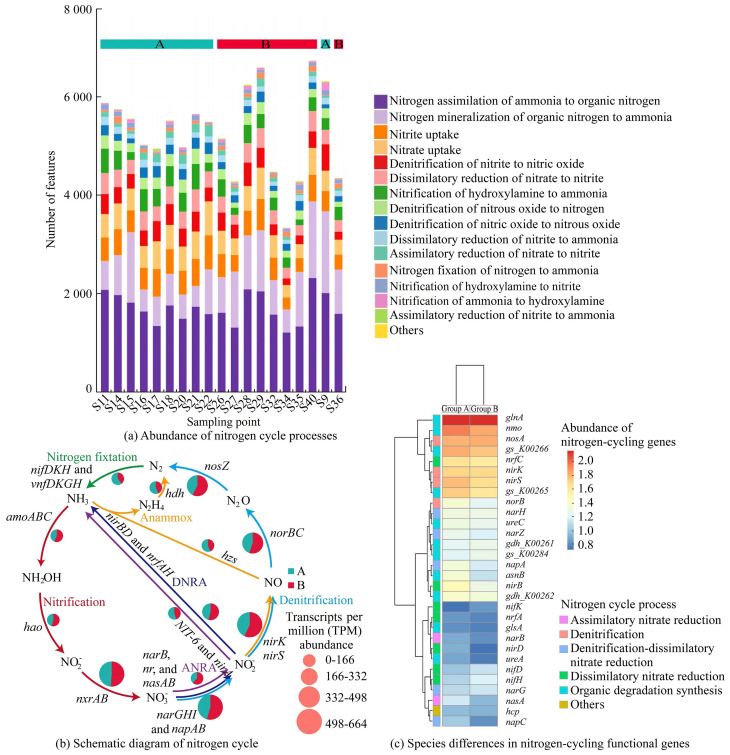
Abstract: Nitrogen pollution in rivers has long been a key environmental factor hindering ecosystem recovery. As critical nodes in water systems, pumping station projects further complicate river environmental issues. This study focused on the pumping stations in the Qinhuai River, a tributary in the lower reaches of the Yangtze River in China, and investigated the mechanisms driving the nitrogen cycle in the forebays of pumping stations through field sampling, metagenomic analysis, and statistical methods. The results indicated that the most abundant phylum of nitrogen-cycling microorganisms in the forebays was Pseudomonadota, accounting for 50.29% of the community. The nitrogen cycle processes were primarily dominated by nitrogen assimilation, nitrogen mineralization, and denitrification. The abundance of denitrification-related genes (nirKS and nosZ) and the diversity and abundance of nitrogen-functional microorganisms were higher in rural areas than in urban areas. NH3-N exhibited a strong correlation with microbial communities in rural areas, while dissolved oxygen (DO) and MnO4- were more closely associated with microbial communities in urban areas. Results from partial least squares path modeling (LS-PM) indicated that the maximum path coefficients in rural and urban areas were 0.315 for denitrification functional genes and 0.687 for nitrogen-mineralization functional genes, respectively. The path coefficient for nitrification in urban areas was greater than those for dissimilatory nitrate reduction and denitrification, suggesting that rural conditions are more conducive to nitrogen removal, while urban conditions favor nitrogen fixation. This study provides significant insights for understanding the ecological processes involved in pumping station water diversion projects.
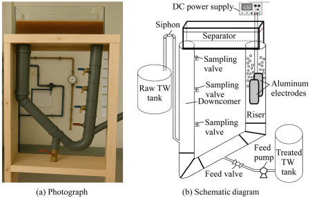
Abstract: Tannery wastewater is a challenging effluent due to its high concentrations of chromium, total sulfides, and recalcitrant organic compounds. This study presented a novel electrocoagulation (EC) process using a self-induced external-loop airlift reactor (ELAR), which operated without mechanical mixing and relied on hydrogen and oxygen microbubbles for internal circulation. Under optimal conditions (pH of 6, a current density of 50 mA/cm2, an electrolysis time of 20 min), the ELAR achieved high pollutant removal efficiencies (88% chemical oxygen demand (COD) removal and 92% Cr removal) with lower energy consumption (10.8 kW·h/m3) and reduced operational costs (1.83 USD per cubic meter) compared to a stirred tank reactor. Artificial neural network (ANN) modeling enabled data-driven optimization, further improving COD removal to 94% with reducing energy input. Kinetic and isotherm analyses confirmed chemisorption as the dominant mechanism. Life cycle assessment (LCA) and solar integration scenarios highlighted the environmental benefits of the ELAR system. Sludge characterization indicated potential for reuse as construction materials. This study uniquely introduced an ELAR system that operates without mechanical agitation, combined with ANN modeling and LCA, representing the first integrated approach for optimizing and assessing EC performance in tannery wastewater treatment. These findings demonstrate that the ELAR system offers a cost-effective and sustainable solution for industrial wastewater remediation.
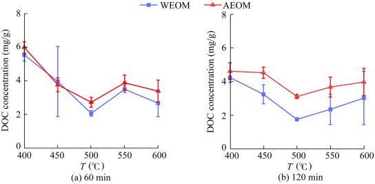
Abstract: Biochar-derived dissolved organic matter (BDOM) plays a crucial role in environmental processes. This study investigated the characteristics of water-extractable organic matter (WEOM) and alkali-extractable organic matter (AEOM) from sludge-derived biochar produced across different pyrolysis temperatures, combining spectroscopic analysis with Fourier-transform ion cyclotron resonance mass spectrometry (FT-ICR MS). Dissolved organic carbon (DOC) concentrations in WEOM and AEOM declined significantly (from 5.72 mg/g to 1.95 mg/g and from 5.93 mg/g to 2.36 mg/g, respectively) with increases in temperature from 400°C to 500°C before increasing again at 600°C. AEOM generally exhibited higher DOC concentrations than WEOM. Three fluorescent components were identified: a humic-like component C1 with two peaks (one at an excitation wavelength (λEx) of 230 nm and an emission wavelength (λEm) of 400 nm and the other at λEx = 310 nm and λEm = 400 nm), an ultraviolet C (UVC) humic-like component C2 with a single peak (λEx = 260 nm and λEm = 460 nm), and a protein-like component C3 with two peaks (one at λEx = 220 nm and λEm = 290 nm and the other at λEx = 285 nm and λEm = 290 nm). AEOM was predominantly composed of polycyclic aromatic compounds, aromatic formulas, lignin, and nitrogen-containing aliphatic compounds, which altogether accounted for more than 75% of its composition. With increasing pyrolysis temperature, the relative abundance of most aromatic structures decreased, while N-aliphatic compounds became more prominent. The humification degree and molecular weight of BDOM increased with temperature rises to 500°C-550°C and then declined, with protein-like C3 peaking within this temperature range. FT-ICR MS revealed a significant reduction in lignin content at 550°C. These results indicate that 500°C-550°C represents a key inflection point in dissolved organic matter (DOM) transformation and an optimal pyrolysis range for producing environmentally favorable biochar.
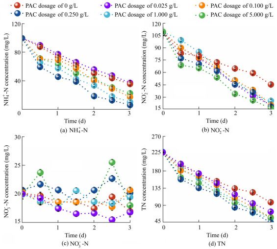
Abstract: Nitrate/nitrite-dependent anaerobic methane oxidation (n-DAMO) coupled with anaerobic ammonium oxidation (anammox) offers an effective approach for removing low-concentration nitrogen from wastewater. However, the slow growth and low metabolic activity of the involved microorganisms limit the overall efficiency of the process. This study investigated the effects of two iron-loaded modified powdered activated carbons (PACs) on synergistic microbial enrichment and nitrogen removal performance. The results showed that the optimal dosages of the unmodified PAC, iron-modified PAC (FePAC), and iron—copper-modified PAC (FeCuPAC) were 0.250 g/L, 0.250 g/L, and 0.025 g/L, respectively, achieving corresponding total nitrogen removal rates of 61.60 mg/(L·d), 68.49 mg/(L·d), and 51.72 mg/(L·d). In short-term experiments, the FePAC group exhibited the highest level of extracellular polymeric substances (134.33 mg per gram of volatile suspended solids) and protein content, which correlated with its superior nitrogen removal performance. The relative abundances of Candidatus Methylomirabilis and Candidatus Methanoperedens in the FePAC group were 45.49% and 6.40% higher, respectively, than those in the control group. This study provides insights into strategies for enhancing the synergistic enrichment of anammox and n-DAMO microorganisms.
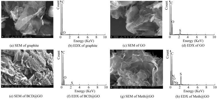
Abstract: Access to clean water remains a critical global challenge. Accordingly, there is an urgent demand for efficient, cost-effective, and environmentally sustainable sorbents for anion removal from water. In this study, biocompatible functionalized graphene oxide (GO) composites were synthesized and evaluated for their performance in removing fluoride and bromide from water. Methionine-functionalized GO (Meth@GO) and β-cyclodextrin-functionalized GO (BCD@GO) with three different loading ratios were prepared for comparison. The influence of co-anions on the removal of both target anions was investigated, with negligible competitive effects observed in water samples. The optimal composites were selected based on application performance and further used to optimize anion removal from simulated and real water samples. Linear and nonlinear models were employed to interpret the adsorption behavior. Nonlinear pseudo-second-order models suitably described the removal of fluoride and bromide by Meth@GO and BCD@GO. The maximum adsorption capacities for fluoride and bromide were 6.57 mg/g and 4.48 mg/g for BCD@GO, and 4.73 mg/g and 3.53 mg/g for Meth@GO, respectively, as determined by nonlinear models. Model results indicated differences between linear and nonlinear findings based on error functions. Both Meth@GO and BCD@GO exhibited strong reusability over four consecutive cycles, with BCD@GO demonstrating superior performance. The removal of both anions from real water samples exceeded 97.31%, highlighting the practical potential of the sustainably synthesized biocomposites.
Abstract: TiO2 nanomaterials are widely regarded as key materials for photocatalytic degradation of antibiotics. However, current research lacks systematic reviews that critically evaluate inconsistent findings or methodological limitations across studies. Existing mechanistic studies suggest that the synergy between TiO2 and metal—organic frameworks (MOFs) can enhance charge separation, extend the light absorption range, and utilize the porous structure of MOFs to adsorb pollutants, thereby collectively improving degradation efficiency. Nevertheless, most conclusions are derived from secondary data without substantial original insights. Advanced characterization techniques have partially revealed structure—activity relationships, and strategies such as heterojunction engineering and bandgap modulation have been employed to overcome the inherent limitations of TiO2. Nonetheless, there remains a notable absence of critical assessment regarding contradictions in experimental results or constraints in current methodologies. Future research should focus on morphology optimization, scalable synthesis routes, and the application of artificial intelligence (AI)-guided material design to facilitate industrial adoption, while also incorporating more primary validation and comparative analyses to resolve existing inconsistencies.
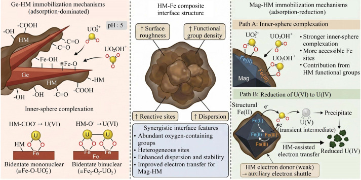
Abstract: Composite systems of soil organic matter and iron hydroxides hold significant potential for the remediation of heavy metal pollution. However, the synergistic immobilization mechanisms of U(VI) by humin (HM)—iron hydroxide composites remain insufficiently understood. In this study, goethite (Ge)—HM and magnetite (Mag)—HM composites with varying C-to-Fe molar ratios were synthesized via co-precipitation, and their adsorption behavior and underlying mechanisms towards U(VI) in aqueous solutions were systematically investigated. The results showed that under conditions of a pH value of 5.0 and temperature of 298 K, the maximum U(VI) adsorption capacities of Ge—HM and Mag—HM reached 60.56 mg/g and 64.12 mg/g, respectively, significantly surpassing those of pure Ge (39.6 mg/g), Mag (22.5 mg/g), and HM (20.2 mg/g). Kinetic studies revealed that the adsorption processes for both Ge—HM and Mag—HM conformed to the pseudo-second-order kinetic model, indicating chemical reaction control. Isothermal adsorption results were well described by the Langmuir model, suggesting monolayer adsorption on the composite surfaces. Crucially, characterization results elucidated distinct reaction mechanisms. Fourier transform infrared spectroscopy (FTIR) and X-ray photoelectron spectroscopy (XPS) analyses revealed that U(VI) primarily complexed with oxygen-containing functional groups, such as carboxyl and hydroxyl groups, on both composite surfaces, leading to stable immobilization. For Mag—HM, a notable reduction of U(VI) to U(IV) was observed, with XPS U 4f spectra showing characteristic U(IV) peaks, indicating a significant reductive immobilization pathway facilitated by the presence of both Mag and HM. In contrast, for the Ge—HM composite with a C-to-Fe ratio of 0.5, the complete consumption of Fe(II) after U(VI) adsorption, with its proportion in total Fe decreasing from 53.7% to zero, strongly suggested that Fe(II) played a key role in electron transfer during the immobilization process. This study elucidates the synergistic enhancement mechanisms of HM—iron hydroxide composites in U(VI) removal, providing new insights for developing green and efficient materials for the remediation of heavy metal pollution.
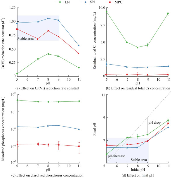
Abstract: Microbial Cr(VI) reduction represents a cost-effective remediation approach, yet its application in continuous-flow systems is often constrained by toxicity inhibition and nutrient instability. This study developed an integrated microbial—phosphorus mineral—corncob (MPC) composite, which encapsulates Cr(VI)-reducing bacteria with slow-release nutrients within a hydrogel matrix. The MPC system sustained complete Cr(VI) removal at influent concentrations up to 160 mg/L in synthetic wastewater and 120 mg/L in actual groundwater, conditions under which conventional systems typically fail. Reactive transport modeling revealed that diffusion limitations create protective intraparticle concentration gradients, while density functional theory (DFT) calculations confirmed strong Cr(III) sequestration and sustained phosphorus bioavailability. The estimated treatment cost is competitive with existing technologies. These findings demonstrate that engineering a protected self-sufficient microbial microenvironment can overcome critical stability limitations in Cr(VI) bioremediation.
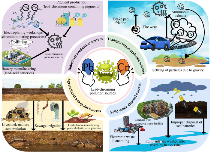
Abstract: Heavy metal contamination poses significant risks to ecosystems and human health. This study comprehensively investigated the mechanisms involved in the simultaneous removal of lead (Pb) and chromium (Cr) composite contaminants using microbially induced carbonate precipitation (MICP) technology. The optimal growth conditions for Sporosarcina pasteurii were determined as follows: a urea concentration of 0.5 mol/L, a Ca2+ concentration of 20 mmol/L, pH of 8, temperature of 30°C, and a carbon source concentration of 10 g/L. Under these specified conditions, MICP achieved synergistic removal efficiencies exceeding 98.98% for Pb(II) and 82.48% for Cr(VI) in the composite contamination system. Analyses utilizing X-ray diffraction (XRD), scanning electron microscopy—energy dispersive spectroscopy (SEM-EDS), and Fourier transform infrared spectroscopy (FTIR) confirmed that Pb(II) was primarily immobilized through carbonate precipitation and mineralization, whereas Cr(VI) followed a dual pathway involving biological reduction and carbonate co-precipitation. Specifically, Cr(VI) was initially reduced to less toxic Cr(III) on the bacterial surface, which subsequently reacted with carbonate ions to form insoluble (Cr,Ca)CO3 compounds. This study provides a sustainable biomineralization strategy for the remediation of heavy metal composite pollutants.
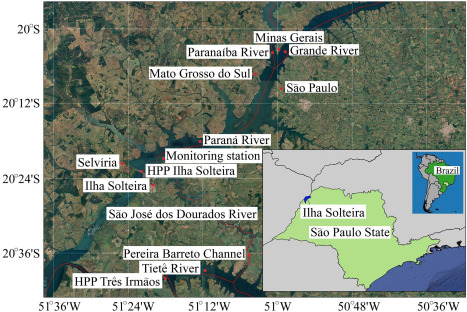
Abstract: Wind waves in reservoirs represent a key hydrodynamic process influencing shoreline stability, navigation safety, and the design of hydraulic infrastructure. Despite their practical relevance, wave prediction in inland waters remains subject to significant uncertainties, particularly related to wind forcing and empirical model parameters. This study integrated deterministic and probabilistic approaches for predicting wind waves in reservoirs. Using a deterministic approach, the Simulating Waves Nearshore (SWAN) model was applied to estimate wave height and period. Key variables analyzed included wind velocity, wind direction, the Joint North Sea Wave Project (JONSWAP) bottom friction coefficient, the whitecapping coefficient, and the depth-induced breaking index. Through a probabilistic approach, uncertainties were quantified using polynomial chaos expansion (PCE), and sensitivity analysis was performed via Sobol indices. This framework was applied to a case study of the Tietê—Paraná Waterway in the Ilha Solteira Reservoir, São Paulo, Brazil. Simulations using the Janssen formulation yielded the most accurate wave height estimates. Sensitivity analysis based on Sobol indices identified wind velocity and the whitecapping coefficient as the most influential factors governing wave behavior. This integrated approach enables the generation of contour maps for wave height and period, offering valuable insights for project planning. Thus, the combination of deterministic and probabilistic analyses enhances the understanding of wind wave dynamics in inland waters.
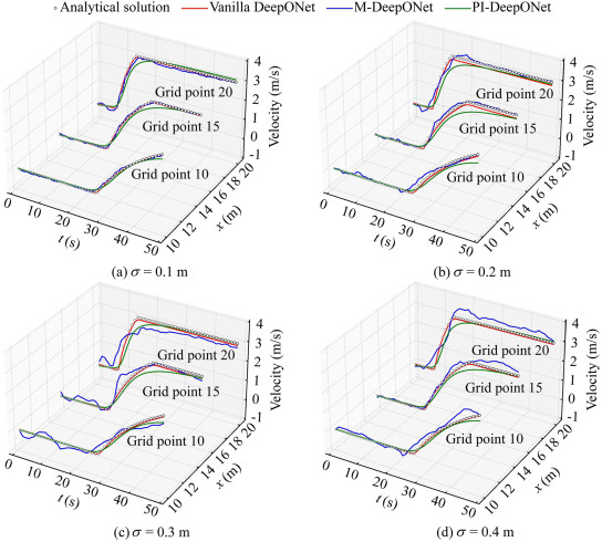
Abstract: Dam-break flows pose significant challenges for accurate and efficient hydrodynamic prediction. This study comprehensively evaluated three DeepONet architectures (vanilla DeepONet, physics-informed DeepONet (PI-DeepONet), and Markov DeepONet (M-DeepONet)) for simulating dam-break hydrodynamics. Extensive numerical experiments exhibited that vanilla DeepONet achieved the highest accuracy, with errors corresponding to only 37.9% and 17.5% of the errors produced by M-DeepONet and PI-DeepONet, respectively. Meanwhile, vanilla DeepONet maintained superior computational efficiency, with a computational duration equivalent to 17.19% of that required by the conventional numerical algorithm. However, its performance was highly dependent on the quantity of training data, with errors increasing by 95.08% as the sampling rate decreased from 100% to 10%. PI-DeepONet exhibited exceptional robustness under data-scarce conditions, with errors amounting to only 24.75% of those observed in vanilla DeepONet at 10% sampling, and it remained stable under high-noise conditions, showing just a 21.9% error increase. M-DeepONet balanced accuracy with sequential prediction capability but suffered from error accumulation in noisy scenarios. These findings reveal distinct trade-offs: vanilla DeepONet excels in data-rich high-accuracy applications, whereas PI-DeepONet is optimal when data are limited or corrupted by noise. This study provides actionable guidelines for model selection in disaster prediction systems, advances operator learning in hydrodynamics, and bridges critical gaps between theoretical development and practical engineering applications.